Monday, May 23, 2011

Illinois


State of Illinois
Flag of IllinoisState seal of Illinois
FlagSeal
Nickname(s): Land of Lincoln; The Prairie State
Motto(s): State sovereignty, national union
Map of the United States with Illinois highlighted
Official language(s)English
Spoken language(s)English (86.8%)
Spanish (4.9%)
Polish (1.6%)
Other (6.7%)
DemonymIllinoisan
CapitalSpringfield
Largest cityChicago
Largest metro areaChicago metropolitan area
Area Ranked 25th in the U.S.
 - Total57,914 sq mi
(149,998 km2)
 - Width210 miles (340 km)
 - Length395 miles (629 km)
 - % water4.0/ Negligible
 - Latitude36° 58′ N to 42° 30′ N
 - Longitude87° 30′ W to 91° 31′ W
Population Ranked 5th in the U.S.
 - Total12,830,632 (2010)
- Density223.4/sq mi  (86.27/km2)
Ranked 12th in the U.S.
 - Median income $54,124 (17)
Elevation 
 - Highest pointCharles Mound
1,235 ft  (377 m)
 - Mean600 ft  (182 m)
 - Lowest pointMississippi River
279 ft  (85 m)
Before statehoodIllinois Territory
Admission to Union December 3, 1818 (21st)
GovernorPat Quinn (D)
Lieutenant GovernorSheila Simon (D)
LegislatureGeneral Assembly
 - Upper houseSenate
 - Lower houseHouse of Representatives
U.S. SenatorsDick Durbin (D)
Mark Kirk (R)
U.S. House delegation11 Republicans, 8 Democrats 
Time zoneCentral: UTC-6/-5
AbbreviationsIL, Ill., US-IL
Websiteillinois.gov

Illinois  is the fifth-most populous state of the United States of America, and is often noted for being a microcosm of the entire country. It is the most populous state in the Midwest region; however with 65% of its residents concentrated in the Chicago metropolitan area, most of the state has either a rural or a small-town character. With Chicago in the northeast, small industrial cities and great agricultural productivity in central and northern Illinois, and natural resources like coal, timber, and petroleum in the south, Illinois has a broad economic base. Illinois is an important transportation hub; the Port of Chicago connects the Great Lakes to the Mississippi River via the Illinois River, and for decades, O'Hare International Airport has ranked as one of the world's busiest airports. As the "most average state", Illinois has long had a reputation as a bellwether both in social and cultural terms and politics.

In the 1810s settlers began arriving from Kentucky; in 1818 Illinois achieved statehood. The state filled up from south to north. Chicago was founded in the 1830s on the banks of the Chicago River, one of the few natural harbors on southern Lake Michigan. Railroads and John Deere's invention of the self-scouring steel plowturned Illinois' rich prairie into some of the world's most productive and valuable farmlands, attracting immigrant farmers from Germany and Sweden. By 1900, the growth of industrial jobs in the northern cities and coal mining in the central and southern areas attracted immigrants from Eastern and Southern Europe. Illinois was an important manufacturing center during both world wars. The Great Migration of African Americans from the rural South to Chicago, established a large community that created the city's famous jazz and blues cultures.Illinois  is the fifth-most populous state of the United States of America, and is often noted for being a microcosm of the entire country. It is the most populous state in the Midwest region; however with 65% of its residents concentrated in the Chicago metropolitan area, most of the state has either a rural or a small-town character. With Chicago in the northeast, small industrial cities and great agricultural productivity in central and northern Illinois, and natural resources like coal, timber, and petroleum in the south, Illinois has a broad economic base. Illinois is an important transportation hub; the Port of Chicago connects the Great Lakes to the Mississippi River via the Illinois River, and for decades, O'Hare International Airport has ranked as one of the world's busiest airports. As the "most average state", Illinois has long had a reputation as a bellwether both in social and cultural terms and politics.
Three U.S. Presidents have been elected while living in Illinois — Abraham Lincoln, Ulysses S. Grant, and Barack Obama. However, the only President actually born and raised in Illinois was Ronald Reagan. Today, Illinois honors Lincoln with its official state slogan, Land of Lincoln, which is displayed on its license plates.

Name


"Illinois" is the modern spelling for the early French missionaries and explorers' name for the Illinois people, a name that was spelled in many different ways in the early records.
The name "Illinois" has traditionally been said to mean "man" or "men" in the Miami-Illinois language, with the original iliniwek transformed via French into Illinois. However, this etymology is not supported by the Illinois language itself, in which the word for 'man' is ireniwa and plural 'men' is ireniwaki. The name Illiniwek has also been said to mean "tribe of superior men", though this is nothing more than a folk etymology. In fact the name "Illinois" derives from the Miami-Illinois verb irenwe·wa "he speaks the regular way". This was then taken into the Ojibwe language, perhaps in the Ottawa dialect, and modified into ilinwe·(pluralized as ilinwe·k). These forms were then borrowed into French, where the /we/ ending acquired the spelling -ois. The current form, Illinois, began to appear in the early 1670s. The Illinois's name for themselves, as attested in all three of the French missionary-period dictionaries of Illinois, was Inoka, of unknown meaning and unrelated to the other terms.

History


Pre-European

Copper plates found at Pre-Columbian burial sites in Illinois.
Native Americans lived along the waterways of the Illinois area for thousands of years before the arrival of Europeans. The Koster Site has been excavated and demonstrated 7,000 years of continuous habitation. Cahokia, the largest regional chiefdom and urban center of the Pre-Columbian Mississippian culture, was located near present-day Collinsville, Illinois. They built more than 100 mounds and a woodhenge in a planned design expressing the culture's cosmology. The civilization vanished in the 15th century for unknown reasons, but historians and archeologists have speculated that the people depleted the area of resources. Many indigenous tribes engaged in constant warfare. According to Suzanne Austin Alchon, "At one site in the central Illinois River valley, one-third of all adults died as a result of violent injuries."
The next major power in the region was the Illinois Confederation or Illini, a political alliance among several tribes. There were about 25,000 Illinois Indians in 1700, but systematic attacks and warfare by the Iroquois reduced their numbers by 90%. Gradually, members of the Potawatomi, Miami, Sauk, and other tribes came in from the east and north. In the American Revolution, the Illinois and Potawatomi supported the American colonists' cause.

European exploration

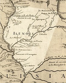
Illinois in 1718, approximate modern state area highlighted, from Carte de la Louisiane et du cours du Mississipi by Guillaume de L'Isle.
French explorers Jacques Marquette and Louis Jolliet explored the Illinois River in 1673. In 1680, other French explorers constructed a fort at the site of present day Peoria, and in 1682, a fort atop Starved Rock in today's Starved Rock State Park. As a result of this French exploration, Illinois was part of the French empire until 1763, when it passed to the British with their conquest of New France. The small French settlements continued; a few British soldiers were posted in Illinois, but there were no British or American settlers. In 1778, George Rogers Clark claimed the Illinois Country for Virginia. The area was ceded by Virginia to the new United States in 1783 and became part of the Northwest Territory.


19th century

Historical populations
CensusPop.
18002,458
181012,282399.7%
182055,211349.5%
1830157,445185.2%
1840476,183202.4%
1850851,47078.8%
18601,711,951101.1%
18702,539,89148.4%
18803,077,87121.2%
18903,826,35224.3%
19004,821,55026.0%
19105,638,59116.9%
19206,485,28015.0%
19307,630,65417.7%
19407,897,2413.5%
19508,712,17610.3%
196010,081,15815.7%
197011,113,97610.2%
198011,426,5182.8%
199011,430,6020%
200012,419,2938.6%
201012,830,6323.3%
Source: 1910-2010]
The Illinois-Wabash Company was an early claimant to much of Illinois. The Illinois Territory was created on February 3, 1809, with its capital at Kaskaskia.
During the discussions leading up to Illinois' admission to the Union, the proposed northern boundary of the state was moved twice.The original provisions of the Northwest Ordinance had specified a boundary that would have been tangent to the southern tip of Lake Michigan. Such a boundary would have actually left Illinois with no shoreline on Lake Michigan at all. However, as Indiana had successfully been granted a 10-mile northern extension of its boundary to provide it with a usable lakefront, the original bill for Illinois statehood, submitted to Congress on January 23, 1818, stipulated a northern border at the same latitude as Indiana's which is defined as 10 miles (16 km) north of the southernmost extremity of Lake Michigan. But the Illinois delegate, Nathaniel Pope, wanted more. Pope lobbied to have the boundary moved further north, and the final bill passed by Congress included an amendment to shift the border to 42° 30' north, which is approximately 51 miles (82 km) north of the Indiana northern border. This shift added 8,500 square miles (22,000 km2) to the state, including the lead mining region near Galena. More importantly, it added nearly 50 miles of Lake Michigan shoreline and the Chicago River. Pope and others envisioned a canal which would connect the Chicago and Illinois rivers, and thusly, connect the Great Lakes to the Mississippi.
In 1818, Illinois became the 21st U.S. state. The capital remained at Kaskaskia, headquartered in a small building rented by the state. In 1819, Vandalia became the capital, and in the next 18 years, three separate buildings were built to serve successively as the capitol building. In 1837, the state legislators representing Sangamon County, under the leadership of state representative Abraham Lincoln, succeeded in having the capital moved to Springfield, where a fifth capitol building was constructed. A sixth capitol building was erected in 1867, which continues to serve as the Illinois capitol today.
Though ostensibly a "free state", Illinois had slavery. The French owned black slaves as late as the 1820s. Slavery was nominally banned by the Northwest Ordnance, but that was not enforced. When Illinois became a sovereign state in 1818, the Ordnance no longer applied, and there were about 900 slaves there. As the southern part of the state, known as "Egypt", was largely settled by migrants from the South, the section was hostile to free blacks and allowed settlers to bring slaves with them for labor. Most citizens were opposed to allowing blacks as permanent residents, and efforts to make slavery official failed in 1822. Nevertheless, some slaves were brought in seasonally or as house servants. The Illinois Constitution of 1848 was written with a provision for exclusionary laws to be passed. In 1853, John A. Logan helped pass a law to prohibit all African Americans, including freedmen, from settling in the state.
In 1832, the Black Hawk War was fought in Illinois and current day Wisconsin between the United States and the Sauk, Fox and Kickapoo Indian tribes. The Indians withdrew toIowa; when they attempted to return, they were defeated by U.S. militia and forced back to Iowa.
The winter of 1830–1831 is called the "Winter of the Deep Snow"; a sudden, deep snowfall blanketed the state, making travel impossible for the rest of the winter, and many travelers perished. Several severe winters followed, including the "Winter of the Sudden Freeze". On December 20, 1836, a fast-moving cold front passed through, freezing puddles in minutes and killing many travelers who could not reach shelter. The adverse weather resulted in crop failures in the northern part of the state. The southern part of the state shipped food north and this may have contributed to its name: "Little Egypt", after the Biblical story of Joseph in Egypt supplying grain to his brothers.
By 1839, the Mormon utopian city of Nauvoo, located on the Mississippi River, was created, settled, and flourished. In 1844, the Mormon leader Joseph Smith was murdered in the Carthage jail. After close to six years of rapid development, the Mormon city of Nauvoo, which rivaled Chicago as Illinois' largest city, saw a rapid decline after the Mormons left Illinois in 1846 for the West in a mass exodus.
Chicago gained prominence as a Great Lakes port and then as an Illinois and Michigan Canal port after 1848, and as a rail hub soon afterward. By 1857, Chicago was Illinois' largest city. With the tremendous growth of mines and factories in the state in the 19th century, Illinois played an important role in the formation of labor unions in the United States. The Pullman Strike and Haymarket Riot in particular greatly influenced the development of the American labor movement. From Sunday, October 8, 1871, until Tuesday, October 10, 1871, the Great Chicago Fire burned in downtown Chicago, destroying 4 square miles (10 km2).
In 1847, after lobbying by Dorothea L. Dix, Illinois became one of the first states to establish a system of state-supported treatment of mental illness and disabilities, replacing local almshouses.

Civil War

During the American Civil War, over 250,000 Illinois men served in the Union Army, a figure surpassed by only New York, Pennsylvania, and Ohio. Beginning with President Abraham Lincoln's first call for troops and continuing throughout the war, Illinois mustered 150 infantry regiments, which were numbered from the 7th to the 156th regiments. Seventeen cavalry regiments were also gathered, as well as two light artillery regiments.

Twentieth century

In the 20th century, Illinois emerged as one of the most important states in the union, with a population of nearly 5 million bolstered by continued immigration from southern and eastern Europe, and by African-Americans from Mississippi, Louisiana, and Arkansas. By the end of the century, the population had reached 12.4 million. The Century of Progress World's Fair was held at Chicago in 1933. Oil strikes in Marion County and Crawford County lead to a boom in 1937, and, by 1939, Illinois ranked fourth in U.S. oil production.
No state has had a more prominent role than Illinois in the emergence of the nuclear age. As part of the Manhattan Project, the first sustained nuclear chain reaction took place at the University of Chicago in 1942. In 1957, Argonne National Laboratory, near Chicago, activated the first experimental nuclear power generating system in the United States. By 1960, the first privately financed nuclear plant in United States, Dresden 1, was dedicated near Morris. In 1967, Fermilab, a national nuclear research facility near Batavia, opened a particle accelerator which was the world largest for over forty years. And, with eleven plants currently operating, Illinois leads all states in the amount of electricity generated from nuclear power.
Chicago became an ocean port with the opening of the Saint Lawrence Seaway in 1959. The seaway and the Illinois Waterway connected Chicago to both the Mississippi River and the Atlantic Ocean. In 1960, Ray Kroc opened the first McDonald's franchise in Des Plaines (which still exists today as a museum, with a working McDonald's across the street).
The state's fourth constitution was adopted in 1970, replacing the 1870 document. The first Farm Aid concert was held in Champaign to benefit American farmers, in 1985. The worst upper Mississippi River flood of the century, the Great Flood of 1993, inundated many towns and thousands of acres of farmland.

Geography


Illinois, showing major cities and roads

Boundaries

Illinois' eastern border with Indiana consists of a north-south line at 87° 31′ 30″ west longitude, from Lake Michigan to theWabash River, above Post Vincennes. The Wabash River continues as the eastern/southeastern border with Indiana, until the Wabash enters the Ohio River. This marks the beginning of Illinois' southern border with Kentucky, which runs along the northern shoreline of the Ohio River. Its western border with Missouri and Iowa is the Mississippi River. Its northern border with Wisconsin is fixed at 42° 30' north latitude. The northeastern border of Illinois actually lies within Lake Michigan, within which Illinois shares a water boundary with the state of Michigan.

Topography

Though Illinois lies entirely in the Interior Plains, it does have some variation in its elevation. In extreme northwestern Illinois, the Driftless Area, a region of unglaciated and therefore higher and more rugged topography, occupies a small part of the state. Charles Mound, located in this region, has the state's highest elevation above sea level at 1,235 feet (376 m). The highest structure in Illinois is Willis Tower with a roof elevation of approximately 2,034 feet (620 m) above sea level. [Chicago elevation (580 ft) + tower height (1454 ft) = 2034.] The floodplain on the Mississippi River from Alton to theKaskaskia River is known as the American Bottom.

Divisions

Illinois has three major geographical divisions. The first is Northern Illinois, dominated by the Chicago metropolitan area, including the city of Chicago, its suburbs, and the adjoining exurban area into which the metropolis is expanding. As defined by the federal government, the Chicago metro area includes a few counties in Indiana and Wisconsin and stretches across much of northeastern Illinois. It is a cosmopolitan city, densely populated, industrialized, and settled by a wide variety of ethnic groups. The city of Rockford, the fourth largest metropolitan area and the state's third largest city sits along Interstates 39 and 90 some 75 miles (121 km) northwest of Chicago. The Quad Cities, located at the western extreme of the area, had a population in 2009 of 379,066. This population makes it the third largest metropolitan area to include area in Illinois, but its area spans two states, as two of the Quad Cities lie in Iowa.
Southward and westward, the second major division is Central Illinois, an area of mostly prairie. Known as the Heart of Illinois, it is characterized by small towns and mid-sized cities. The western section (west of the Illinois River) was originally part of the Military Tract of 1812 and forms the distinctive western bulge of the state. Agriculture, particularly corn and soybeans, as well as educational institutions and manufacturing centers, figure prominently. Cities include Peoria, the third largest metropolitan area in Illinois at 370,000; Springfield, the state capital; Quincy; Decatur; Bloomington-Normal; and Champaign-Urbana.
The third division is Southern Illinois, comprising the area south of U.S. Route 50, and including Little Egypt, near the juncture of the Mississippi River and Ohio River. Southern Illinois is the site of the ancient city of Cahokia, as well as the site of the first state capital, at Kaskaskia which today is separated from the rest of the state by the Mississippi River. This region can be distinguished from the other two by its warmer climate, different variety of crops (including some cotton farming in the past), more rugged topography (due to the area remaining unglaciated during the Illinoian Stage, unlike most of the rest of the state), as well as small-scale oil deposits and coal mining. The Illinois suburbs of St. Louis comprise the second most populous metropolitan area in Illinois with over 700,000 inhabitants, and are known collectively as theMetro-East. The other significant concentration of population in Southern Illinois is the Carbondale-Marion-Herrin, Illinois Combined Statistical Area centered on Carbondale and Marion, a two-county area that is home to 123,272 residents. A portion of southeastern Illinois is part of the extended Evansville, Indiana Metro Area, commonly referred to as the Tri-State with Indiana and Kentucky. Seven Illinois counties are in the area.
In addition to these three, largely latitudinally defined divisions, all of the region outside of the Chicago Metropolitan area is often called "downstate" Illinois. This term is flexible, but is generally meant to mean everything outside the Chicago-area. Thus, some cities in Northern Illinois, such as Rockford – which is actually north of Chicago – and DeKalb, which is west of Chicago, are considered to be "downstate".

Climate

Because its nearly 400 miles (644 km) distance from its northernmost and southernmost extremes, as well as its mid-continental situation, Illinois has a widely varying climate. Most of Illinois has a humid continental climate (Köppen climate classification Dfa), with hot, humid summers and cold winters. The southernmost part of the state, from about Carbondale southward, borders on a humid subtropical climate(Koppen Cfa), with more moderate winters. Average yearly precipitation for Illinois varies from just over 48 inches (1,219 mm) at the southern tip to around 35 inches (889 mm) in the northern portion of the state. Normal annual snowfall exceeds 38 inches (965 mm) in the Chicago area, while the southern portion of the state normally receives less than 14 inches (356 mm). The all time high temperature was 117 °F(47 °C), recorded on July 14, 1954, at East St. Louis, Illinois, while the all time low temperature was −36 °F (−38 °C), recorded on January 5, 1999, at Congerville, Illinois.
Illinois averages around 51 days of thunderstorm activity a year, which ranks somewhat above average in the number of thunderstorm days for the United States. Illinois is vulnerable to tornadoes with an average of 35 occurring annually, which puts much of the state at around five tornadoes per 10,000 square miles (30,000 km2) annually. The deadliest tornadoes on record in the nation have occurred largely in Illinois, not because the tornadoes are more common or frequent in Illinois, but rather, because Illinois is simply the most populous state in Tornado Alley. The Tri-State Tornado of 1925 killed 695 people in three states; 613 of the victims lived in Illinois. Modern developments in storm tracking have caused death tolls from tornadoes to dramatically decline since the 1960s, with no major losses of life since the 1967 tornado storm in northern Illinois.
CityJanFebMarAprMayJunJulAugSepOctNovDec
Cairo41/2547/2957/3969/5077/5886/6790/7188/6981/6171/4957/3946/30
Chicago30/1636/2147/3059/4071/5181/6185/6583/6575/5764/4548/3436/22
Edwardsville36/1942/2452/3464/4575/5584/6489/6986/6679/5868/4653/3541/25
Moline30/1236/1848/2962/3973/5083/6086/6484/6276/5364/4248/3034/18
Peoria31/1437/2049/3062/4073/5182/6086/6584/6377/5464/4249/3136/20
Rockford27/1133/1646/2759/3771/4880/5883/6381/6174/5262/4046/2932/17
Springfield33/1739/2251/3263/4274/5383/6286/6684/6478/5567/4451/3438/23